The SkyFISH platform is a dedicated web-based service that can be used by the end-users as a decision support tool for finding the most favourable fishing zones or analyze the suitability of specific areas for aquaculture activities and monitoring of the existing ones. It takes full advantage of the multiple Earth Observation resources available through Copernicus Marine Service concerning essential oceanographic parameters.
SkyFISH stands for "Service for water quality monitoring for sustainable fishing and aquaculture in the Romanian Coastal area".
All datasets are updated daily, thus users have access to the most up-to-date products at any momment. Exception is the mussels suitability index, which is based on long-term analysis datasest and which is updated irregularly.
[READMORE]
Earth Observation data can be used to identify Potential Fishing Zones (PFZ) allowing fishermen to work in a more efficient way. Satellite data can also offer solutions to examine environmental issues, by measuring the most important parameters of the ecosystem that are highly related with distribution of marine resources. The main objective of the SkyFISH service is to offer a user-friendly collaborative platform based mainly on satellite derived information, suitable for identification of the most favourable fishing and aquaculture areas in Romanian coastal waters.
Challenges and Issues to be overcome by the service:
SkyFISH was developed and is maintained by TERRASIGNA. The National Institute for Marine Research and Development "Grigore Antipa" contributed with expertise in terms of fisheries and aquculture.
The service addresses multiple categories of stakeholders:
SkyFISH service is free to be used by any registered user. The following details are required from user for registration process: first and last name, institution, e-mail address and password setup.
Interested stakeholders can use the fishing suitability index, which is updated daily based on Copernicus Marine Environment Monitoring Service forecast products, to better prepare and maximise the efficiency of fishing campaigns. The mussels aquaculture index, available over a 20 years period, should be consulted when analyzing the suitability to install new farms.
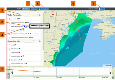
Oceanographic parameters available through the Copernicus Marine Service (http://marine.copernicus.eu), along with information available from other sources are integrated in the SkyFISH geo-portal. The main added-value products derived based on these datasets are the suitability indices for fishing and aquaculture activities (Generated using E.U. Copernicus Marine Service Information).
Datasets from Copernicus Marine Service currently integrated into SkyFISH are presented bellow.
| Black Sea Physics Analysis and Forecast | BLKSEA_ANALYSIS_FORECAST_PHYS_007_001 |
| Black Sea Physics Reanalysis | BLKSEA_REANALYSIS_PHYS_007_004 |
| Black Sea Monthly and 8-days Reprocessed Surface Chlorophyll Concentration from Multi Satellite Observations + SeaWiFS Daily Climatology | OCEANCOLOUR_BS_CHL_L4_REP_OBSERVATIONS_009_079 |
| Global Ocean NRRS, BBP, CDM, KD, ZSD, SPM (Copernicus-GlobColour) from Satellite Observations: Monthly, 8-days, Daily-Interpolated (Reprocessed from 1997) | OCEANCOLOUR_GLO_OPTICS_L4_REP_OBSERVATIONS_009_081 |
| Black Sea High Resolution and Ultra High Resolution Sea Surface Temperature | SST_BS_SST_L4_NRT_OBSERVATIONS_010_006 |
| Black Sea Monthly, 8-Days and Daily Interpolated Surface Chlorophyll Concentration from Multi Satellite and Sentinel-3 OLCI observations | OCEANCOLOUR_BS_CHL_L4_NRT_OBSERVATIONS_009_045 |
SkyFISH offers access to two distinct categories of products:
1. Essential oceanographic variables, both forecast (modeled) and analysis (observations), which can be used to investigate the environmental status at specific moments. These are useful for both fishing and aquaculture stakeholders. For example, an algal bloom event might be detected using the chlorophyll concentration products. Such events are of interest to mussels farms and to fishing vessels as well.
2. Suitability indices:
2.1. Whiting suitability index denotes the areas that are favorable or not for fishing. Indices for other species are foreseen to be implemented in the future. The current index is provided as a forecast product, thus enabling fishermen to use it as a predictive tool to better prepare their fishing campaigns. It was calibrated and validated using in-situ measurements (catches) and it is based on three distinct primary parameters: temperature, salinity and bathymetry.
2.2. Mussels aquaculture suitability index is a monthly product, available for the 1998-2017 time period. It can be used in order to detect areas where mussels growing can have the highest success rate. It is based on several primary indicators: temperature, salinity, bathymetry, chlorophyll concentration and water turbidity.
[READMORE]
The entire envisaged database for the SkyFISH service is synthetically shown in the following diagram.
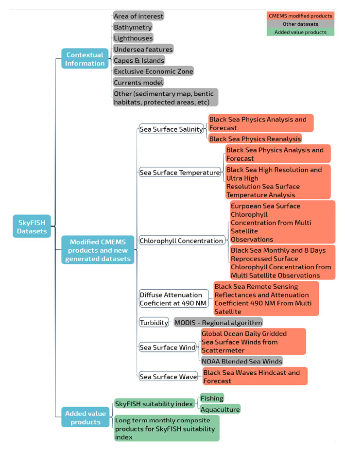
The integration of Copernicus Marine Service products, as derived and added-value datasets, has a twofold purpose:
1. First is to disseminate information regarding essential ocean related parameters through a user-friendly collaborative platform that offers advanced functionalities to inspect and analyze the datasets. The Copernicus Marine Service products can be visualized and analyzed in parallel with other sources of information, such as bathymetry, submerged feature etc, thus putting them into a broad context that is oriented towards the needs of the foreseen users.
2. The second purpose is to use these Copernicus Marine Service provided layers of information in order to create a suitability index for fishing and aquaculture activities. This represents a synthetic overview of the entire set of information provided by the system (added-value products), meaning Copernicus Marine Service products plus other sources of information.
The core components of the service are the suitability indices for fishing and aquaculture activities - the added-value products. These are determined based on several essential oceanographic parameters and modeled according to habitat quality indicators for each species.
[READMORE]
Copernicus Marine Environment MonitoringService products bring, in an seamless and operational way, information regarding important oceanographic parameters, in a timely manner. Integration of such datasets allows the development of downstream services that can bridge the gap between researchers and stakeholders in multiple domains. Such an endeavour is undertaken also by the SkyFISH platform, which has as main objective the dissemination of state of the art Earth Obsevation information to fisheries and aquaculture sectors.
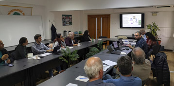
A SkyFISH workshop was held on 23 October 2019 in Constanta, at the National Institute for Marine Research and Development "Grigore Antipa". The implementation team presented the main results of the project in front of more than 20 actors involved in fishing and aquaculture activities from Romanian industry and academia. After the presentation, a practical training about the usage of SkyFISH geoportal was conducted. The workshop was finalized with a round table discussion session. The feedback received from the users will greatly benefit the future improvements of the service. Important details regarding the fine tuning of the fishing/aquaculture suitability indices were gathered and will be soon implemented.
[READMORE]
Between October 7 and 12, the SkyFISH team participated to the Ocean Optics XXIV Conference in Dubrovnik, Croatia. For this event, a poster presentation was prepared, focused on the integration of products based on optical remote sensing information into the SkyFISH platform. The received feedback will help improve the service. New contacts have been made with other interested parties and scientist involved in projects related to the aquaculture and fisheries applications of Earth Observation data.
The 4th GEO Blue Planet Symposium (https://geoblueplanet.org/blue-planet-symposiums/4th-blue-planet-symposium-toulouse-2018/) hosted by Mercator Ocean took place took place between July 4 - 6, 2018 in Toulouse, France. During the symposium, issues regarding ocean and coastal information needs for sustainable development, Blue Growth and sociatal awarness were brought to attention and debated.
TERRASIGNA team, part of the SkyFISH consortium, was presented at 4th GEO Blue Planet Symposium with a poster presentation about SkyFISH geoportal.

[READMORE]
The main components and functionalities of the SkyFISH client module: